|
 Algonquin
Park: Ontario’s wilderness legacy Algonquin
Park: Ontario’s wilderness legacy
by Wayne Bridge
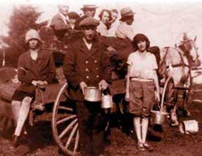
Photo: Berry pickers near the Highland
Inn. Photo by Johanna Martin. Algonquin Park Archives 2395
Prior to the 1830s, the area that was
to become Algonquin Park was primarily the hunting, fishing,
and trapping grounds of various bands of Algonquin native
people. Because of its harsh climate, jagged topography, and
accessibility only by birch bark canoe, they didn’t actually
live in the area. For them it was a larder and source of income
from the commercial sale of furs trapped in the district.
After the War of 1812, however, the governing
bodies of Lower and Upper Canada felt it wise to establish
a water route—strategically located further removed from
the American border—from the upper Great Lakes to Lower
Canada. During the 1820s and ‘30s several Royal Engineer
survey expeditions traversed parts of what is now Algonquin
Park. Lieutenant Henry Briscoe, in 1826, is thought to be
the first white person to enter the future border of the Park
when he completely explored a west-east river route from the
Oxtongue River to the Petawawa and on to the Ottawa River.
As any modern-day canoe tripper will affirm, his route was
not a possible communication or commercial alternative to
the lower Great lakes—too many portages!
Aside from political strategy, there were
two other groups, in addition to the ever-present fur trappers,
interested in the Algonquin highlands: settlers and loggers.
The timbermen got there first. Mostly due to the Napoleonic
Wars, Britain’s demand for North American square timber
was insatiable. Logging reached the Algonquin area by the
1830s and has continued to this day. When the pine were gone
and the square timber trade died (by mid-century), the sawlog
business took over. A construction boom was underway in the
United States and later in the new province of Ontario. Algonquin
wood was in great demand.
The 1880s brought a man with vision—Alexander
Kirkwood, Chief Clerk of the Land Sales Division of the Ontario
Department of Crown Lands. He saw the ominous portent of conflicting
demands for the Algonquin Highlands area. There was a possibility
of the Opeongo Colonization Road cutting a swath from Renfrew
to Georgian Bay, thus clearing the way for settlement; the
railroad had reached Huntsville by 1885, and plans were in
place for a line stretching from Whitney to Parry Sound; trappers
and hunters were decimating the wildlife; and loggers continued
to drop trees at a rapid rate.
Kirkwood feared the Algonquin district
would suffer the same fate as the landscape of southern Ontario—forests
fragmented, rivers dammed and polluted, and wildlife extirpated.
In 1886 he wrote a letter to the Commissioner of Crown Lands
outlining his fears and offering his remedial suggestions.
With the support of Crown Surveyor, James Dickson, a Royal
Commission was struck with the happy ending being the passing
of the Algonquin Park Act (May 27,1893), creating Ontario’s
beloved park as a wildlife and forest preserve (although logging
was allowed to continue); a health refuge; and field laboratory
for scientific study.
The appointed Park Superintendent, Peter
Thomson, set up the new park’s headquarters close to
the west boundary at Canoe Lake. The Gilmour Lumber Company
had that same year established a centre—Mowat, named
after then- Premier of Ontario, Oliver Mowat—for its
logging operations.
But logging was not the first item of
concern for the fledgling park’s administrators—poaching
was. Trappers had been setting lines in these areas for decades
before the establishment of a reserve. Although park rangers
were hired from the beginning, poaching for game and furs
continued to be a major problem until the introduction of
airplane surveillance in the winter of 1932.
The year 1897 was a pivotal time for Algonquin
National Park (so named until 1913, although it has always
been under provincial jurisdiction). It marked the official
opening of Ottawa lumber tycoon J.R. Booth’s Ottawa,
Arnprior and Parry Sound Railroad that crossed the southern
portion of the Park from Whitney to Kearney, establishing
Algonquin’s umbilical cord to civilization.
With the trains came tourists, and following
soon after were hotels, lodges, cottages and camps. The progression
of advancements continues today, but also wise curtailments—the
removal of hotels, some lodges and camps, and the terminating
of leases by 2017. The following is a chronological list of
some of these developments:
- 1897 Park Headquarters moved down the
rail line to Cache Lake
- 1911 First telephone lines strung along
railway telegraph poles
- 1915 Canadian Northern Railway completed
through the north of the park
- 1933 Construction of Highway 60 through
the Park begun
- 1935 First automobiles entering the
Park on Highway 60 (still only dirt and gravel)
- 1938 Lake of Two Rivers Campground
opened
- 1939 Airplane hanger built at Smoke
Lake
- 1940 Highway 60 opened in winter for
first time and used by the first lumbering trucks
- 1948 Highway 60 paved
- 1953 Bell Telephone line through the
Park along Highway 60
- 1954 The Park’s interpretive program
started
- 1959 Headquarters moved to the east
gate and trains came to Cache Lake for the last time
- 1963 First Public Wolf Howl
- 1974 Algonquin Park Master Plan published
and Algonquin Forestry Authority established
- 1983 The Friends of Algonquin Park
formed
- 1993 Centennial and opening of the
Visitor Centre
- 1996 The last train entered the Park
on the northern CNR Line
- 1997 The Friends of Algonquin Park
launch www.algonquinpark.on.ca
This is a mere outline, but the important
point is while Algonquin Park has progressed with the times
and technology, it has remained—and in some ways reverted
to—a semi-wilderness experience for explorers of its
interior. In fact, it has more than doubled in size since
the original 3,755 square kilometres in 1893. Campgrounds
and easily-accessed lakes lack some of the wildness that Alexander
Kirkwood sought to save but the experience is not greatly
diminished. Algonquin retains a charm—a mystique—that
has drawn people throughout the ages.
This is an original story,
first published in The Country Connection Magazine,
Issue 47, Autumn 2004. Copyright Wayne Bridge.
RETURN
TO STORY INDEX
RETURN
TO BACK ISSUE PAGE
|