|
 Fort
Willow Fort
Willow
by Andrew Hind
When one thinks of the forts of Ontario,
the magnificent stone bastions built by Britain to defend
the province from American hostility invariably come to mind.
Among them are Forts York, Niagara, and Henry. Those perhaps
more versed in history might remember the Hudson Bay Company
trading posts of the northwest. But, only the most astute
students of Ontario’s heritage will recall Fort Willow
(sometimes called Willow Creek Depot), despite the important
role it played during the War of 1812.
Many fortifications were constructed during
this war against the United States, most of which were a temporary
expedience, duly abandoned at the conflict’s end. Fort
Willow is the only example that remains of these short-lived
structures, and even it fell into disuse and was reclaimed
by the forests. Indeed, for decades it was lost amongst the
trees, and was only rediscovered in the 1950s when Wilfred
and Elsie Jury, a pair of eminent archaeologists, began to
excavate the site. Twelve years later, their work was completed,
and a remarkable picture emerged of the fort and those who
served there. The Fort Willow Improvement Group is currently
lovingly restoring the site to a state as it would have appeared
during the War of 1812.
The fledgling United States of America
declared war against Britain in 1812, the result of a national
fever for war inspired by rumoured British incitement of Native
attacks and several inflammatory maritime incidents between
the two nations.
Hoping to take advantage of British
preoccupation with the war against Napoleon then raging in
Europe, Congress declared war on June18th, 1812. They believed
Canada could be wrested from the British Empire and added
to the Union with relative ease. The Americans underestimated
British and Canadian resolve.
The conflict was a seesaw affair
from the start, both sides making gains and suffering defeats.
In the summer of 1812, however, Commander Oliver Hazard Perry
decisively beat a Royal Navy squadron in the Battle of Lake
Erie. This victory ensured American domination of the lake,
thereby cutting British lines of communication to Lake Huron
and her isolated forces at Fort St. Joseph and Michilimackinac
on Lake Superior. With the majority of her resources tied
up in the European conflict, retaking control of the lake
was not an option for England, at least not in the short term.
To skirt American naval supremacy
on Lake Erie, the British took advantage of an overland route
from York (Toronto) to Lake Huron, used for centuries by Natives
and fur traders. The route lay overland from Fort York up
to the Humber River, which was followed north to Fort Gwillimbury
(modern day Holland Landing). From there, supplies and personnel
would transfer into boats to traverse the Holland River to
Lake Simcoe, and then across to Kempenfelt Bay (Barrie). There,
the Nine Mile Portage led through the wilderness to Willow
Creek, which fed into the Nottawasaga River and hence into
Lake Huron at Wasaga.
The route was less than ideal. Narrow
paths twisted through an imposing wilderness, down rivers
incapable of supporting large craft, and through dense swamp
that was every bit as forlorn as the Everglades of Florida,.
Nevertheless, for several years it supported the British military
effort in the northwest.
It was a truly remarkable feat of
logistics and human endurance.
At the end of the Nine Mile Portage,
a fort was hacked out of the dark forest. Located on a plateau
overlooking Willow Creek and the vast Minesing Swamp, Fort
Willow defended the vulnerable route from attack and acted
as a supply depot for forces operating in the north. A contemporary
has described the location as a “hellish and malarial
place,” yet the fort was quite sizeable and housed a
significant garrison.
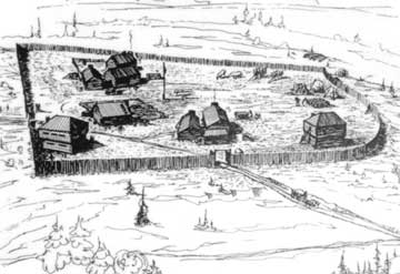
Fort Willow boasted several log
houses, a barn, and two blockhouses (strong points for defence;
what we would call bunkers), surrounded by a wooden palisade
measuring 180 feet by 250 feet and beyond that, extensive
trench works. The garrison numbered 250 men at its peak, including
20 Royal Navy shipwrights brought from Kingston to build bateaux
for service on the river and Lake Huron. The bulk of the fighting
force was composed of men from the Royal Newfoundland Regiment,
hardy soldiers well-accustomed to frontier warfare, as well
as a token detachment of artillery. The force was commanded
by Lt. Colonel Robert McDouall of the Glengarry Light Infantry,
a man described as an imposing and energetic figure and an
inspiring leader. A conventional British officer, he nonetheless
adapted to the rigours and hardships of frontier warfare much
better than many of his brethren, and he is undoubtedly one
of the unsung heroes of the war.
The shipwrights proved their worth
over the winter of 1813-14, constructing 29 bateaux that were
used by McDouall to resupply and reinforce the isolated forts
on the northern end of Lake Huron in the spring. Without relief,
these forts likely would have fallen to American siege and
the outcome of the war may have been far different. In all
likelihood, the modern Canada-US border would be significantly
altered west of Lake Erie.
The overland route and Fort Willow
played an important role throughout the war, and well beyond.
While the majority of the garrison was removed as soon as
the war ended, the route remained in use for some time, until
roads could be cut through the wilderness to the naval garrison
at Penetanguishene. In the meantime, it was used by several
notable explorers, including David Thompson on his way back
from exploring the west, and Sir John Franklin, who passed
through in 1825 on the initial leg of his epic Arctic voyage
of discovery. Inevitably, when the road to Lake Huron was
completed, the Nine Mile Portage fell into disuse and Fort
Willow was forgotten.
There has been extensive debate
about whether a village sprang up in the shadow of the fort.
Writing in 1948, local historian Andrew Hunter was adamant
there was indeed a settlement: “In consequence of the
great amount of traffic quite a little village grew up at
the northwest terminus of the Willow Creek Portage.”
His view has been supported by Robert Thom, an expert on Georgian
Bay history, who noted that workers laying tracks for the
CPR dug up graves that suggested a village existed between
1816-1830. Many modern historians remain dubious, as archaeological
work has yet to uncover any evidence to support this theory.
We may never know for sure.
The Fort Willow Improvement Program
is in the early stages of reconstructing the fort to a state
as it was during the War of 1812, conforming to exacting archeological
specifications. Several signs and maps have been erected on-site,
detailing the history and importance of the fort and the painstaking
efforts to rebuild it.
A fresh palisade is in the midst
of construction, and the foundations for the buildings laid
out. Searching among the trees, you will find the earthworks,
still readily apparent after nearly 200 years.
Few people know of Fort Willow,
perhaps because of its out-of-the-way location. Only nine
miles from Barrie, it feels like you are in the middle of
virgin wilderness, or perhaps in another time. The forest
here is gloomy somehow, almost primordial. It’s not hard
to imagine the tribulations of those soldiers as they struggled
over the portage from Kempenfelt Bay, encumbered with packs
weighing up to 60 lbs., and making perhaps three to five miles
per day through the dense undergrowth. Seeing the palisade
through the trees for the first time is an odd rush. It feels
distinctly out of place in such an isolated locale, as does
the Union Jack that flies proudly from the flagpole. But this
is actually beneficial to the whole experience. The low rate
of visitors means you often have the fort to yourself, a far
cry from what you experience during the tourist season at
Forts York and Henry.
The conservation area is open year
round, although the extensive network of walking trails that
lead from the fort down into the Minesing Swamp is not maintained
in the winter. Access to the park is free, but small donations
for the costs of rebuilding the site are welcome. Special
events are occasionally hosted here, from living history re-enactors
to Halloween-themed tours. Contact the Fort Willow Improvement
Group for more information at (705)424-1479.
Fort Willow Creek can be found in
the Fort Willow Conservation Area, nine miles (obviously)
west of Barrie. Take Highway 90 west, and then turn right
on Grenfel Road. About four miles further on, you will see
the conservation area on your left, the palisades just visible
through the trees.
This is an original story,
first published in The Country Connection Magazine,
Issue 42, Spring 2003. Copyright Andrew Hind.
RETURN
TO STORY INDEX
RETURN
TO BACK ISSUE PAGE
|